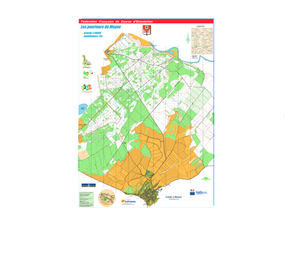


Les pourtours de Moyen
| Numéro : 2014-D54-189 | Carte : 1 |
| Spécialité : Rand'O | Niveau : Départemental |
| Échelle : 1/15000 | Surface : 16,36 km² |
| Cartographes : POGU Philippe, FATH Jean Marie, CHAPELOT Lucas | |
| Commune la plus proche : MOYEN | |
| Propriétaire : 54 - Meurthe-et-Moselle | |
| Comment et où obtenir la carte. Responsable à contacter :
- POGU Philippe, Abbaye Saint Mansuy, 54200, TOUL, |
|